Geographical Maps
OpenNMS includes a geographical map which can show nodes with address asset information on a world map, including dynamic alarm status.
The geographical map is located under Geographical Map in the side menu or by going to the page of a node that has an address and/or longitude/latitude defined in its asset fields, and following the View in Geographical Map link.
Markers and clusters
The geographical map displays each node that has an associated longitude and latitude in the database. If a node does not have coordinates recorded, update the requisition to include address asset fields and verify the geocoder service is configured and enabled.
The geographical map automatically clusters nodes into groups if they are close together. A marker with a number in it indicates a cluster and the number of nodes in it. Hover over a cluster to show the contents of the nodes it contains. Click on a marker to show the summary of the nodes it contains.
Status
A node’s marker displays as the color associated with the most severe alarm for that node. A cluster’s marker displays as the color of the highest severity of the nodes the marker contains.
| Severity | Map Pin |
|---|---|
Normal |

|
Warning |

|
Minor |

|
Major |

|
Critical |

|
Tile providers
Tile providers are services that provide the image data (in the form of map tiles) for the geographical map. By default, OpenNMS uses the publicly available OpenStreetMap and OpenTopoMap.
However, if you need to use your own map server, for example on a local server inside a firewall, you can specify a user-defined tile provider.
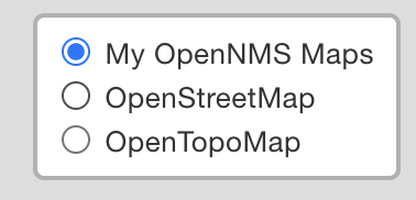
To select among tile providers, follow these steps:
-
Click the tile symbol
 on the geographical map.
 -
Select a provider from the list:
User defined tile provider configuration
To configure a user-defined tile provider, follow these steps:
-
In
etc/opennms.properties, use the configuration below. In this case the local tile provider is found at192.168.0.99. -
Set
gwt.openlayers.nameto provide a display name
If you specify a user-defined tile provider, it will be the default (displays as the first one, and loads by default instead of the built-in providers).
The opennms.properties file that is installed with Horizon already contains an entry for the OpenNMS tile provider.
|
Instead of editing the opennms.properties file directly, you should create a .properties file in the etc/opennms.properties.d folder with your override properties.
|
###### MAPPING AND GEOCODING ######
# The tile server URL to use for OpenLayers. This can be any mapnik-style tile server URL.
# (Sorry, no support for multiple URLs yet.)
# OpenNMS default tile server
gwt.openlayers.name=My Street Map
gwt.openlayers.url=http://192.168.0.99/{z}/{x}/{y}.png
gwt.openlayers.options.attribution=Map data © <a tabindex="-1" target="_blank" href="http://192.168.0.99/copyright">My Street Map</a> contributors under <a tabindex="-1" target="_blank" href="192.168.0.99/licenses/odbl/">ODbL</a>, <a tabindex="-1" target="_blank" href="http://192.168.0.99/licenses/by-sa/2.0/">CC BY-SA 2.0</a>-
In addition, if you supply a user-defined tile provider, you need to update the
'Content-Security-Policy'of your OpenNMS instance to ensure the browser does not block the tile provider.-
In
jetty-webapps/opennms/WEB-INF/web.xml, search for the section shown below. -
Update the
param-valueunder Sets the header value to include your tile provider’s URL in theimg-srcsection. The example below adds the URLhttp://192.168.0.99.
-
  <filter>
    <description>Set Content-Security-Policy header</description>
    <filter-name>Content-Security-Policy-Filter</filter-name>
    <filter-class>org.opennms.web.servlet.AddHeaderFilter</filter-class>
    <init-param>
      <description>Sets the header key.</description>
      <param-name>key</param-name>
      <param-value>Content-Security-Policy</param-value>
    </init-param>
    <init-param>
      <description>Sets the header value.</description>
      <param-name>value</param-name>
      <param-value>default-src 'none' ; frame-src 'self' ; manifest-src 'self' ; script-src 'self' 'unsafe-inline' 'unsafe-eval'; font-src 'self' https://fonts.googleapis.com  https://fonts.gstatic.com; connect-src 'self' ; style-src 'self' 'unsafe-inline' https://fonts.googleapis.com; base-uri 'self' ; form-action 'self' ; img-src 'self' https://tiles.opennms.org https://*.tile.openstreetmap.org https://*.tile.opentopomap.org http://192.168.0.99 data:</param-value>
    </init-param>
  </filter>